Creating Datasets for Location Intelligence
Table of Contents
What Is Location Intelligence?
Location intelligence refers to the process of gathering, analyzing, and utilizing spatial data to gain insights and make informed decisions. It involves the integration of geographic information system (GIS) technology, business intelligence tools, and data analytics to understand the relationships between location-based data and other business or social factors. Location intelligence helps organizations understand patterns, trends, and relationships within a geographic context, enabling them to optimize operations, target customers, plan logistics, and make data-driven decisions.
A location intelligence dataset is a collection of spatial data. It typically includes various types of geospatial information such as maps, points of interest, boundaries, routes, demographics, and environmental data. Location intelligence datasets can be used in multiple industries such as retail, real estate, logistics, urban planning, healthcare, and marketing, among others, to gain insights into customer behavior, optimize resource allocation, improve transportation networks, and enhance overall operational efficiency. These datasets can be derived from a wide range of sources, including satellite imagery, government agencies, private companies, and crowd-sourced data. Targetron is one of those sources.
Targetron: Reliable and Fresh Source of Location Intelligence Data
Targetron provides advantages to its users in many ways. These include a large, up-to-date, and reliable database, advanced filtering capabilities, and more. In addition, it offers the opportunity to quickly access all datasets with its ease of use
Major Benefits of Using Targetron for Location Intelligence
- Pay-As-You-Go: There is no fixed monthly fee at Targetron. You download the dataset you need and only pay for it.
- Up-To-Dateness: Targetron’s database is always up to date. The database is periodically updated and edited.
- Database Size: Targetron is powered by the largest data sources in the world. The database covers all countries of the world. And contains more than five thousand categories.
- Instant Access: You don’t need to wait to reach datasets in Targetron. After determining the necessary filters and seeing the preview of the dataset, you can directly download it.
- Advanced Filtering Capabilities: Targetron offers advanced filtering options to reach the most suitable dataset for your needs.
How to Use It?
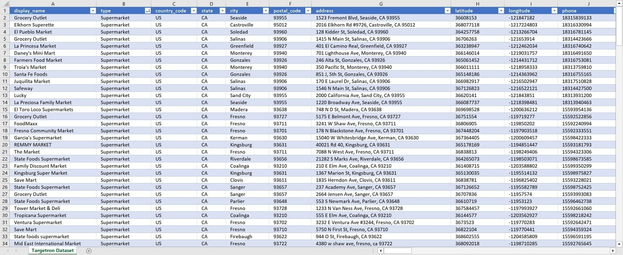
As an example, for a company that works for supermarkets and does location intelligence analysis, using Targetron is very productive. On the Targetron service page, it is sufficient to select the “Supermarket” category and a location, as follows.
A list of all supermarkets in that location will appear in front of it. It is possible to download the list of all these supermarkets at once by pressing the “Export Results” button.
The result file can be downloaded in CSV, XLSX, JSON, and PARQUET file formats. Thus, it can be quickly imported into any software used while preparing the location intelligence report and can be used as a data layer.
If you operate in the location intelligence industry and need extensive local company data or POI data, Targetron is the ideal choice to fulfill all your requirements. Targetron is known for its quality and reliability, making it a dependable and trustworthy source. When it comes to meeting your specific needs, you can confidently rely on Targetron. Please read our tutorial for more:
Explore Targetron’s Database for Location Intelligence
An extensive database and user-friendly interface make Targetron a valuable resource for businesses and industries seeking POI data for location intelligence. Targetron ensures that the information provided is accurate and reliable, making it a trusted solution for accessing location intelligence datasets and databases. We invite you to explore Targetron’s database to enhance your location intelligence capabilities.
FAQ
Most frequent questions and answers
Location intelligence data refers to spatial data that is gathered, analyzed, and utilized to gain insights and make informed decisions. It involves the integration of geographic information system (GIS) technology, business intelligence tools, and data analytics to understand the relationships between location-based data and other business or social factors. Location-based data can be obtained from large and reliable databases such as Targetron.
An example of location intelligence is the analysis of customer data to understand their behavior and preferences based on their geographic location. For instance, a retail company can use location intelligence, with data provided by Targetron, to identify the most profitable store locations based on customer demographics, competition, and proximity to target markets.
Location Intelligence is used for various purposes across different industries. It helps organizations understand patterns, trends, and relationships within a geographic context, enabling them to optimize operations, target customers, plan logistics, and make data-driven decisions. Companies like Targetron provide extensive databases and accurate POI (Points of Interest) data for professionals seeking data for location intelligence.
Location Intelligence for tracking refers to the use of spatial data to monitor and track the movement of people, assets, or vehicles in real time. This can be useful in fleet management, supply chain optimization, asset tracking, and emergency response planning. Targetron, a reliable source of Location Intelligence data, offers datasets for locations that can assist companies in tracking and monitoring their assets or vehicle routes effectively.